The Pinnacles
Just 12 miles south of Eastern, there is a geographic feature known as the Pinnacles. Berea College owns the land, which consists of about four square miles of forest. Since I first discovered this place quite by accident, I go there as much as possible just to get out into nature and get some good views of the surrounding country.
 The Pinnacles lie on what is the very edge of the Cumberland Escarpment (or Pottsville, depending on who you are). About 380 million years ago, the North American tectonic plate buckled, resulting in the uplift of the Cumberland Plateau to the south and the creation of the Bluegrass Region to the north. You can see this for yourself in the first image. The elevation gain from north to south between these two regions is more or less 500 feet.
At the base of the Pinnacles there is a large amphitheatre called Indian Fort Theater. It was built in 1955 for something like $100,000. An outdoor wedding was the only event I have seen take place in this theater, otherwise it just sits empty and the bathroom doors are always locked.
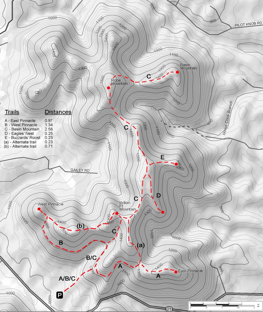
Right past the theater, a single trail begins. All the trails here are well maintained, I assume by Berea students or faculty. There are about 5.4 miles of trails—if one could hike all trail legs without walking the same leg twice. Since last September, I have managed to hike all the visible trails and to visit all the summits.
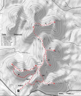 The most popular destination for hikers seems to be the East and West pinnacles. The East pinnacle offers a good view of the town of Bighill, while from the West pinnacle there is an excellent view of Berea. I prefer the 2.5-mile hike to Basin Mountain. On a clear day, Richmond can be seen from here (remember, 12 miles away) and is by far the most isolated summit, as I have never encountered hikers this far out.
Many times I have encountered people on the more popular trails who have no idea where they are going. Most just want to get to the best view. I usually recommend the east or west side or sketch them a quick map in the dirt to direct them, along with a rough ETA or distance estimate.
I wondered why Berea College hadn’t taken the time to print some kind of map to direct hikers along their way. I decided to take it upon myself to make one. Using my GPS, I measured the distances of all the major trail legs. Once I double-check my measurements on future hikes, I plan to send my map to the forestry department of Berea College. I will recommend either printing some of the maps for free distribution at the beginning of the trail, or the construction of a small sign to display an enlarged copy of the map.
Until then, if you are in Richmond, Berea, or at least know of the Pinnacles, feel free to try out this map, and let me know if anything is confusing or needs to be changed.
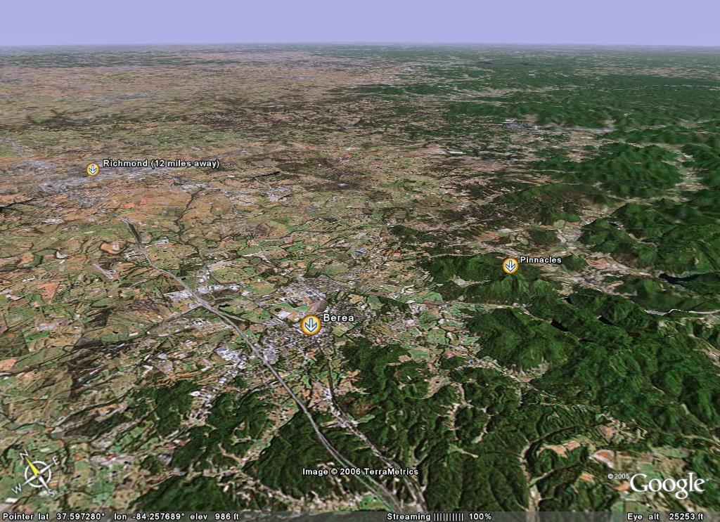 The Pinnacles lie on what is the very edge of the Cumberland Escarpment (or Pottsville, depending on who you are). About 380 million years ago, the North American tectonic plate buckled, resulting in the uplift of the Cumberland Plateau to the south and the creation of the Bluegrass Region to the north. You can see this for yourself in the first image. The elevation gain from north to south between these two regions is more or less 500 feet.
At the base of the Pinnacles there is a large amphitheatre called Indian Fort Theater. It was built in 1955 for something like $100,000. An outdoor wedding was the only event I have seen take place in this theater, otherwise it just sits empty and the bathroom doors are always locked.
Right past the theater, a single trail begins. All the trails here are well maintained, I assume by Berea students or faculty. There are about 5.4 miles of trails—if one could hike all trail legs without walking the same leg twice. Since last September, I have managed to hike all the visible trails and to visit all the summits.
 The most popular destination for hikers seems to be the East and West pinnacles. The East pinnacle offers a good view of the town of Bighill, while from the West pinnacle there is an excellent view of Berea. I prefer the 2.5-mile hike to Basin Mountain. On a clear day, Richmond can be seen from here (remember, 12 miles away) and is by far the most isolated summit, as I have never encountered hikers this far out.
Many times I have encountered people on the more popular trails who have no idea where they are going. Most just want to get to the best view. I usually recommend the east or west side or sketch them a quick map in the dirt to direct them, along with a rough ETA or distance estimate.
I wondered why Berea College hadn’t taken the time to print some kind of map to direct hikers along their way. I decided to take it upon myself to make one. Using my GPS, I measured the distances of all the major trail legs. Once I double-check my measurements on future hikes, I plan to send my map to the forestry department of Berea College. I will recommend either printing some of the maps for free distribution at the beginning of the trail, or the construction of a small sign to display an enlarged copy of the map.
Until then, if you are in Richmond, Berea, or at least know of the Pinnacles, feel free to try out this map, and let me know if anything is confusing or needs to be changed.
posted by Elliott Marlow at 7:18 PM
![]()


4 Comments:
hi Elliott, went to the Pinnacles for the first time today and printed out your map beforehand. many thanks worked a treat! (they still have no maps there btw)
Charlie
I'm going to try your map this afternoon (It's national trails day. I appreciate the effort, and I'll let you know how it worked out.
Good job on the map. I really appreciate it.
Thanks for map!!!
Post a Comment
<< Home